Thursday, March 31, 2005

Final Daywalk

I finished my training with a walk from Cherrybrook to North Ryde. This
was approximately 20km, (OK, maybe a little less). I ran a bit of the
way (maybe 5km) as I was a bit late. Overall, it took 3.5 hours.

Everything was OK gear wise - shoes with old orthotics, shorts and
t-shirt. Now for the real thing. I'll have to watch the following during
the walk:

* any hot spots on my feet should be tended to immediately
* likewise for any chaffing hot spots
* make sure I consume enough salt to avoid cramping
* enough carbs and protein to get me through the day, night, and day
again
* sore knees may require Ibuprofen, or knee braces
* wet and/or cold weather may present other challenges
* we should swap the lead, so no one is leading the whole time
* we need to stick together, which I may find hard to do

Fingers crossed!

Tuesday, March 29, 2005

Berowra Daywalk


This day's training was planned to mimic the Trailwalker, in terms of pace (actually, I expect our Trailwalker pace to be a bit slower), clothing (or at least foorwear) and backpack (spot on with this one), so what better place to do it than the Sydney trailwalker course.


I set off from Cherrybrook, and headed for Berowra waters, which is also the Benowie section of the Great North Walk, a walk from Sydney to Newcastle. I got dropped off at about 8:40, and settled into a brisk but manageable pace. I was planning to do the 25km walk in about 5 hours, so there were to be no bludge stops.

The day was already quite warm, and I was very surprised by the pleasant scenery, which followed the creek (the one that goes through Galstone Gorge) all the way, with only a few ups and downs, to get around the incumbant sydney sandstone cliffs that frequetly line creeks like this.

Most of the route follows a well worn track, but there were a few sections of fire trail. Harry the happy hiker always cropped up at major intersections to point me in the right direction, so there were no navigation dilemas (I didn't have a map - just a nose for the right direction).

A burnoff had taken place the day before, so I got to walk through a smokey section, for about 2km. There were still a few burning bushes about, and the haze seemed to trap in more heat. This section was closed by the Bush fire brigade, but I saw no sight of them that day, and ignored there warnings. But I could easily see it could have been unsafe - a few trees had collapsed across the track, and a few more were propped up by nothing more than a few twigs.

I crossed a creek, whcih was signposted as "The Fishponds", which ended up being some large, naturally occurring wells or holes (moulins?) gouged into the rocks by the water. Easy to see where its name came from.
I ran into a bunch of girl guides, out for some adventure. I hope they had a nice day.

Towards the end of the walk, a ran for a few minutes, to try and make up time so I wouldn't be late for my ride home. Unfortunately, he too was late, but fortuantely, a bunch of scouts were selling drinks at the Bewrora Punt (the walk ends on the west side, away from the shops), so I could refresh myself before we had a lazy afternoon.

Overall
* fantastic views along the creek, which is surprising for somewhere so close to sydney
* not much evidence of development, which is surprising for somewhere so close to sydney (a few roads to cross, but not much more)
* I should really treat the Trailwalker a bit like an Ironman in terms of nutrition, instead of waiting to get hungry before eating (I was starting to get a bit weaker towards the end of the walk)
* drinking from my Camelbak was just fine
* I won't wear my new orthotics, as they gave me a slight blister
* if I get sore spots in the trailwalker, they must be tended to immediately
* I need to do another long walk, using my old orthotics (the new shoes were OK)

Berowra creek widens near the Punt.

Berowra Creek - close to the city, and pretty!


Freycinet


So instead of three days high in the South West wilderness of Tasmania, we ended up in the picturesque, but populated Freycinet Peninsula. This area has experience tremendous gowth in the past few years, and sees a lot of tourist traffic. Fortunately, the National Parks seem to be regulated the flow reasonably well, and the local community has adopted a environmental mindset, eg by banning plastic bags from all their shops.

Dave piked, due to a dodgie knee, but Dan and I headed off, initially powering past the lumberers, despite our overnight packs. The view was pretty speccie, even though the weather was overcast. After some posing for the obligatory photos, we headed off along the beach. Sand obviously makes beach walking hard, but at least you don't have any hills to climb.

Away from the happy snappers, we enjoyed the trek up to Mt Freycinet, the highest point on the peninsula. The wind and slight elevation made it a bit cooler, but once we were out of the wind, headed towards our campsite, things became quite pleasant.

Our destination for the night, a very pleasant site by the beach, was much more populated than I expected. There were about 5 parties slung out by the beach, most of them probably on a 3 or 4 day walk.

That night, we made our aquaintance with some yanks from the site next to ours, who were all studying at Hobart Uni. And whilst on the beach, we copied the yoga moves of some girls from Melbourne. The late sunset meant we could enjoy some seaweed skipping
(!), rock throwing (I knackered Harry the Happy Hiker) and some Algae Glowing.


Algae Glowing


After dark, jump up and down right at the high point of an incoming wave (wait til the water subsides before you jump). Just after you jump, luminescant algae glow a bluey green colour, concentrated at the high water point on the sand. If you jump along the beach, you can see where the last wave rolled up to. Entertainment value 6.3/10.

Once we had enough of the beach, we returned to camp (all of 10m from the beach) for some dessert (dessert is spelt with 2 s's, as you always have a double helping of dessert), just in the knick of time. Possums had started to come out, and these ones were well and truly used to humans. The first one scared my by sneaking up between Dan and myself, despite being only 1m apart. She had her baby on her back, and Dan decided to pluck it of her back. The mother scampered away, whilst the baby dangled, limbs flagging wildy, until Dan dropped it.

We spent the next little while shoring up our food supplies, making them possum proof. Later, I heard about possums in this area unzipping tents and packs so they could gorge on some chocolate. Crafty little bastards.

The next morning, food intact, we set off along the coast. The seaside track was enjoyable walking, probably due to the fantastic weather. A pod of dolphins swam past, and we entered for a dip too.

The day was not very strenuous, which suited our tiring bodies perfectly. We made it back around lunch time, met up with Dave, and headed back to Hobart for our flight back home.


A perfect day on one of the world's prettiest beaches.

Why do backpacker ads have pictures of people with their arms in the air? Dunno.

This is as far as most tourists get - thankfully.


Day Walks - Tasman Peninsula, Mt Anne, Mt Field


After my trip to Frenchmans Cap, and a night in Hobart, I headed out to pick up Dan and Dave from the airport. (You can get cheap parking by parking in the rental car area - helps if you actually have a rental car, though.) We kept on heading to the

Tasman Peninsula, stopping at some of the many points of interest, including:
  • tesselated pavement (very square, looks unnatural)
  • the beach (cold, but much warmer than Ottawa)
  • Eaglehawk neck, where dogs stopped escaping convicts at the isthmus (and I broke some ancient driftwood in front of the cafe)
  • various blow holes and their relatives
  • Port Arthur (walk in the exit, and you don't have to pay)

We took 4 hours to visit the Totem Pole, a feature on my hit list (ever since I saw a picture of it in Climb Magazine - and there were climbers there too). 'Twas a nice walk out and back, with big cliffs, a bit of wind, and a seal (as discovered by Dave).

That night, we headed out to Lake Pedder (or Gordon) (seeing a numbat on the way), to get ready for our 3 day walk up Mt Anne. We camped at the track head, and the following morning I drove the car 7km to the end of the circuit (and walked back) to avoid a long road bash at the end of the walk. The morning was very overcast, but we were optimistic none-the-less. The walk starts across a swampy area, but before long, you are climbing up the ridge towards Mt Anne. Unfortunately, the cloud wasn't lifting, and we were steadily nearing its ceiling.

Eventually, at the a nice little hut, we reached that day's roof. There were a few others around, waiting for the weather to improve. One guy even ventured up for a bit, only to return speaking of crazy white stuff falling from the sky. Hmm.

After not much debate, we decided to pike, and returned to our starting point (now sans car). Fortunately, there were people (the climbers from the Totem Pole, actually) willing to give Dan a ride to the rental car.

Now with some unplanned days up our sleeve, we ended up at Mt Field National Park, an oft overlooked area, despite its spectacular alpine scenery. I was very impressed by it - much open heath, tarns, cliffs and scree slopes. The circuit we chose for the day went past an aptly named Lake Webster (Woo Hoo), as well as a couple of huts, one of which had been restored into a fantastic museum. The area is (during cold winters) a ski area, and we walked past a couple of the ski lifts, as well as some ski lodges.

Next, we headed for the coast, but only after we stopped at the Styx Valley, an area of environmental combat. The Tasmanian Logging Company has put up a nice walk going past the Big Tree, and the Bigger Tree, and explaining the environmental way in which they harvest timber. One kilometre around the corner, is Greenpeace's version of events, next to some clear cut land, with their walk visiting the big stump and Reg, the tree which protesters lived in until it got too cold (about April). It was great to see the contrasting messages and styles of propaganda. Should be more of it.

Friday, March 25, 2005


The Totem Pole, on Port Arthur (note the rope - climbers were on this) Posted by Hello

Port Arthur Posted by Hello

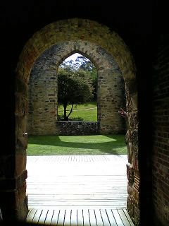
Some Archway on the Tasman Peninsula Posted by Hello